
GIS Mapping of Lake Erie Vineyards
Rhiann Jakubowski, Program Assistant - GIS
Lake Erie Regional Grape Program
November 19, 2012
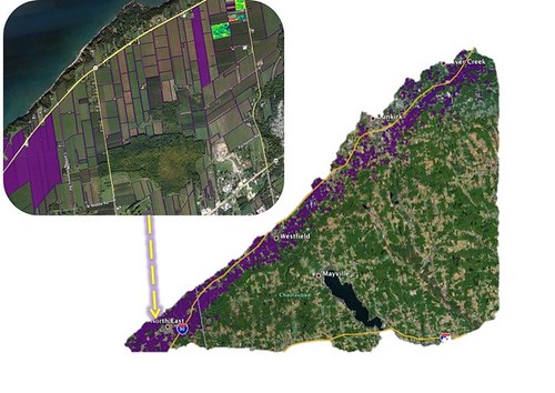 In 2011, individual vineyard block boundaries in the Lake Erie grape belt region were manually mapped using ArcGIS software with funding provided by Cornell Cooperative Extension Administration Special Smith Level Funding. Currently, the vineyard polygons are being edited to include ownership and variety of each separate block. Elevation and soil data were also added to give growers a unique perspective of their property. Individualized maps for acreage & variety, elevation, and soil type are provided, free of charge, to grape growers who participate by identifying their vineyard block operations. Growers were informed about this service through weekly coffee pot meeting, growers, conferences, newsletters, and through the weekly Crop Update. Surveys to assess the impacts of the generated maps on vineyard best management practices were then distributed to the participating growers. This project is still continuing, and block maps are still available for those who are interested.
Upcoming Events
LERGP Coffee Pot Meeting #10
July 15, 2026 : LERGP Coffee Pot Meeting #10
Newfane, NY
Back to our regular coffee pot meetings at grower locations- bring a chair, some good questions and a smile.
LERGP Coffee Pot Meeting #11
July 22, 2026 : LERGP Coffee Pot Meeting #11
Ripley, NY
Back to our regular coffee pot meetings at grower locations- bring a chair, some good questions and a smile.
2027 LERGP Winter Grape Grower Conference
March 18, 2027 : 2027 LERGP Annual Winter Grape Grower Conference
Fredonia, NY
2027 Winter Grower Conference
Announcements
Your Trusted Source for Research-Based Knowledge